Sign in
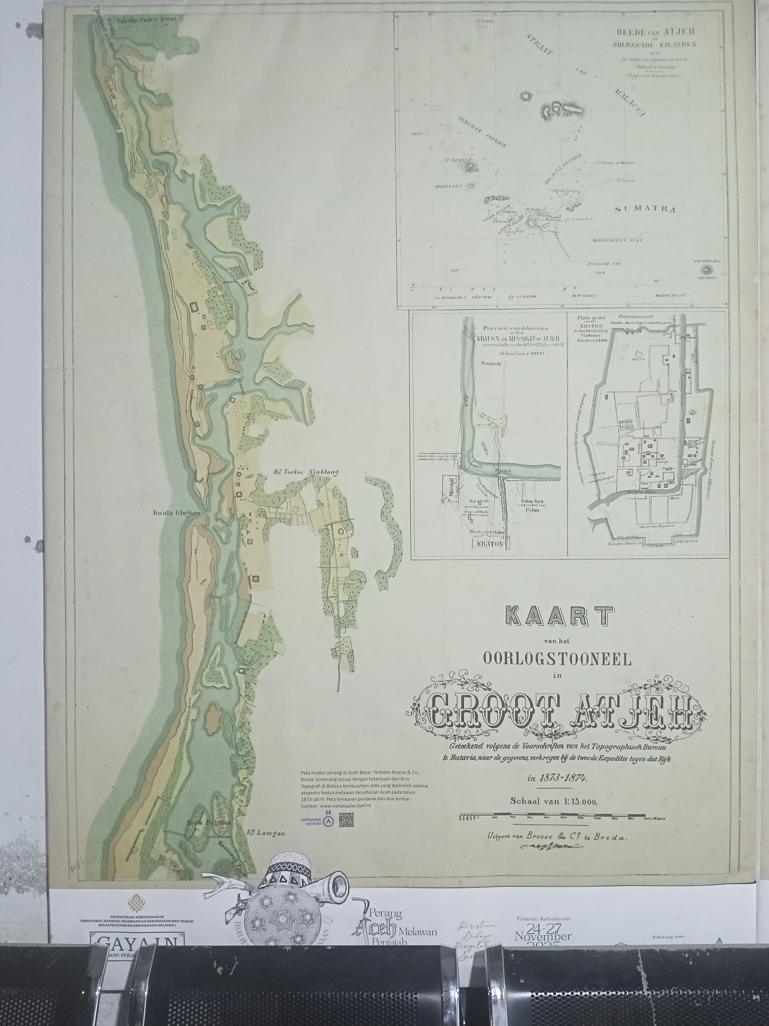
The image is a scanned, aged map titled "KAART van het OORLOGSSTOONEEL in GROOT ATJEH in 1873-1874". The map depicts a coastal area with rivers, villages, and fortifications, likely representing a strategic region during a military conflict. The top left section of the map shows a detailed view of a river mouth labeled "Kwala Ginchen" and a populated area with numerous structures. To the right of this detailed section is a smaller inset map labeled "REEDE VAN ATJEH en OMLIGGENDE EILANDEN 1873", showing the Bay of Aceh and surrounding islands, including Sumatra. The main map includes labels in Dutch, such as "Kwala Ginchen", "Kwala Nedai", and "Kè Tockor Njalang". Below the main map, there are two detailed plans of fortified locations labeled "Plattegrond KRAION en MISSIGIT te ATJEH" and "Platte grond KRATON in den omtrek van Banda Atjeh". These plans show intricate layouts of buildings, walls, and strategic points. A scale bar and a legend are also present on the map. The overall condition of the map suggests it is a historical document, with some discoloration and visible fold lines. The bottom of the image shows modern elements, including seals and text in Indonesian, suggesting the map is part of a larger document or exhibition. Based on the title "GROOT ATJEH" and the location of Banda Aceh in Indonesia, this map depicts a region in the vicinity of the modern-day city of Banda Aceh, which was the capital of the Aceh Sultanate and a central point of conflict during the Aceh War. The fortifications and military context indicate it is a historical map of military significance for the area.
curisea

Jun 10, 2026, 8:30 PM

Banda Aceh, Indonesia

Moment

Stake attention in this memory

historical
geographic
cartographic
detailed
documentary

The image is a scanned, aged map titled "KAART van het OORLOGSSTOONEEL in GROOT ATJEH in 1873-1874". The map depicts a coastal area with rivers, villages, and fortifications, likely representing a strategic region during a military conflict. The top left section of the map shows a detailed view of a river mouth labeled "Kwala Ginchen" and a populated area with numerous structures. To the right of this detailed section is a smaller inset map labeled "REEDE VAN ATJEH en OMLIGGENDE EILANDEN 1873", showing the Bay of Aceh and surrounding islands, including Sumatra. The main map includes labels in Dutch, such as "Kwala Ginchen", "Kwala Nedai", and "Kè Tockor Njalang". Below the main map, there are two detailed plans of fortified locations labeled "Plattegrond KRAION en MISSIGIT te ATJEH" and "Platte grond KRATON in den omtrek van Banda Atjeh". These plans show intricate layouts of buildings, walls, and strategic points. A scale bar and a legend are also present on the map. The overall condition of the map suggests it is a historical document, with some discoloration and visible fold lines. The bottom of the image shows modern elements, including seals and text in Indonesian, suggesting the map is part of a larger document or exhibition. Based on the title "GROOT ATJEH" and the location of Banda Aceh in Indonesia, this map depicts a region in the vicinity of the modern-day city of Banda Aceh, which was the capital of the Aceh Sultanate and a central point of conflict during the Aceh War. The fortifications and military context indicate it is a historical map of military significance for the area.

Symbol

B0E60

Volume

11,537

Creator

+$0.04

Revenue

+$0.03

TVL

$2.70

1D
1W
1M
All

Loading AttnAds…

transactions
revenues
stakers
Earliest
Latest
Highest stake

1

CM🤖

Staked 2mo ago

$2.59 USD

+$0.00 USD

0%

2

Safar Iqbal

Staked 2mo ago

$0.05 USD

-$0.00 USD

-0.4%

3

Rev Bot 🤖💰

Injected revenue 2mo ago

Revenue bonus for the last stake.

+$0.00 USD

4

irfan

Staked 2mo ago
Redeemed 1mo ago

$1.36 USD

-$0.01 USD

Fee: $0.00 (0.25%)

-0.7%

5

Rev Bot 🤖💰

Injected revenue 2mo ago

Revenue bonus for the last stake.

+$0.04 USD

6

bond

Staked 2mo ago

$0.05 USD

-$0.00 USD

-0.5%

7

Rev Bot 🤖💰

Injected revenue 2mo ago

Revenue bonus for the last stake.

+$0.00 USD

More from this user

More from Banda Aceh

curisea

Jun 10, 2026, 8:30 PM

Banda Aceh, Indonesia

Licensed under Creative Commons Attribution 4.0 International License. You are free to share and adapt this content with proper attribution.