
Sign in
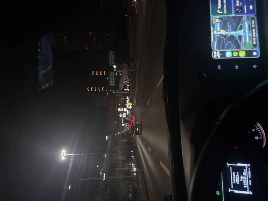
The image depicts a nighttime scene from the interior of a vehicle, looking forward through the windshield onto a multi-lane urban highway. The perspective is consistent with a driver's viewpoint.

The location is identified by a green overhead road sign indicating "MEXICO Centro," "ATLIXCO Centro," and "AV. 15 SUR," placing the scene in the vicinity of San Bernardino Tlaxcalancingo, Mexico, a town adjacent to Puebla City on the route towards Atlixco.

The environment is an urban highway at night, illuminated by numerous bright streetlights and the lights of other vehicles. Multiple vehicles with illuminated taillights are visible ahead in various lanes, indicating active traffic. Tall buildings with illuminated windows are discernible in the background, including a prominent high-rise structure on the far right. Additional illuminated commercial signs and billboards are visible in the distance. A pedestrian overpass is present above the right side of the highway.

Inside the vehicle, the steering wheel and dashboard are visible in the foreground. The instrument cluster on the left displays digital text including "Autonomia 450km" (range 450km), "Viaje 1052.8km" (trip 1052.8km), and an odometer reading of "11082 km." An infotainment screen on the right side of the dashboard shows a navigation map with a blue route, displaying "10:33" (time), a 5G signal icon, "740 m Carriles Laterales" (740 meters Lateral Lanes), and an estimated arrival time of "10:48 Llegada 15 min." No individuals are directly visible.
Tatoo

Mar 7, 2026, 4:33 AM

San Bernardino Tlaxcalancingo, Mexico

Stake attention in this memory

NightDrive
Navigation
Urban
Calm
Routine

The image depicts a nighttime scene from the interior of a vehicle, looking forward through the windshield onto a multi-lane urban highway. The perspective is consistent with a driver's viewpoint. The location is identified by a green overhead road sign indicating "MEXICO Centro," "ATLIXCO Centro," and "AV. 15 SUR," placing the scene in the vicinity of San Bernardino Tlaxcalancingo, Mexico, a town adjacent to Puebla City on the route towards Atlixco. The environment is an urban highway at night, illuminated by numerous bright streetlights and the lights of other vehicles. Multiple vehicles with illuminated taillights are visible ahead in various lanes, indicating active traffic. Tall buildings with illuminated windows are discernible in the background, including a prominent high-rise structure on the far right. Additional illuminated commercial signs and billboards are visible in the distance. A pedestrian overpass is present above the right side of the highway. Inside the vehicle, the steering wheel and dashboard are visible in the foreground. The instrument cluster on the left displays digital text including "Autonomia 450km" (range 450km), "Viaje 1052.8km" (trip 1052.8km), and an odometer reading of "11082 km." An infotainment screen on the right side of the dashboard shows a navigation map with a blue route, displaying "10:33" (time), a 5G signal icon, "740 m Carriles Laterales" (740 meters Lateral Lanes), and an estimated arrival time of "10:48 Llegada 15 min." No individuals are directly visible.

Loading AttnAds…

transactions
revenues
stakers
Earliest
Latest
Highest stake

No transactions found

More from this user

More from San Bernardino Tlaxcalancingo

Tatoo

Mar 7, 2026, 4:33 AM

San Bernardino Tlaxcalancingo, Mexico

Licensed under Creative Commons Attribution 4.0 International License. You are free to share and adapt this content with proper attribution.