Sign in
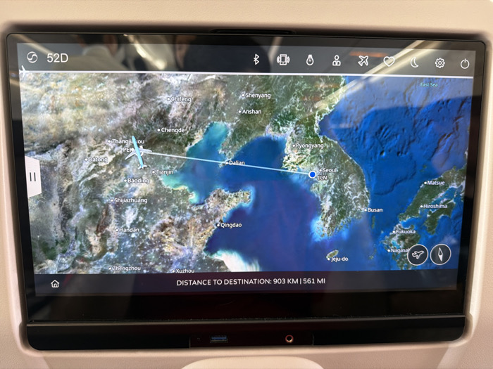
The image, captured in the city of Chaoyang District, China, depicts an in-flight entertainment (IFE) screen within an aircraft cabin. The screen displays a detailed satellite-style flight map of East Asia, encompassing eastern China, the Korean Peninsula, and surrounding sea areas.

An light blue stylized airplane icon is positioned over mainland China, west-northwest of Beijing (labeled PEK). A thin white line, representing the flight path, extends from this airplane icon across the Yellow Sea towards Seoul, South Korea (labeled ICN). Prominent city labels visible include Beijing, Tianjin, Dalian, Qingdao, Shenyang, Pyongyang, Seoul, and Busan.

The top left of the screen shows "S 52D", likely a seat identifier, alongside a small airplane icon. A status bar across the top right features various interface icons, including Bluetooth, Wi-Fi, headset, passenger services, airplane mode, a heart icon, a moon icon, settings (gear), and a power button.

At the bottom center of the screen, the text "DISTANCE TO DESTINATION: 903 KM | 561 MI" is visible. A white "||" (pause) icon overlays the left side of the map. Indistinct reflections of at least two human figures are present in the upper portion of the glossy screen, indicating passengers seated behind the photographer.

Below the screen, a dark bezel integrates a USB port (with a blue interior, suggesting USB 3.0 or later) and a 3.5mm audio jack, recessed into the surrounding light-colored panel of the aircraft seatback. The overall scene indicates an active flight in progress, with a passenger utilizing the IFE system.
S
Serg

Mar 22, 2026, 5:47 AM

Chaoyang District, China

Stake attention in this memory

Anticipation
Excitement
Wanderlust
Curiosity
Restlessness

The image, captured in the city of Chaoyang District, China, depicts an in-flight entertainment (IFE) screen within an aircraft cabin. The screen displays a detailed satellite-style flight map of East Asia, encompassing eastern China, the Korean Peninsula, and surrounding sea areas. An light blue stylized airplane icon is positioned over mainland China, west-northwest of Beijing (labeled PEK). A thin white line, representing the flight path, extends from this airplane icon across the Yellow Sea towards Seoul, South Korea (labeled ICN). Prominent city labels visible include Beijing, Tianjin, Dalian, Qingdao, Shenyang, Pyongyang, Seoul, and Busan. The top left of the screen shows "S 52D", likely a seat identifier, alongside a small airplane icon. A status bar across the top right features various interface icons, including Bluetooth, Wi-Fi, headset, passenger services, airplane mode, a heart icon, a moon icon, settings (gear), and a power button. At the bottom center of the screen, the text "DISTANCE TO DESTINATION: 903 KM | 561 MI" is visible. A white "||" (pause) icon overlays the left side of the map. Indistinct reflections of at least two human figures are present in the upper portion of the glossy screen, indicating passengers seated behind the photographer. Below the screen, a dark bezel integrates a USB port (with a blue interior, suggesting USB 3.0 or later) and a 3.5mm audio jack, recessed into the surrounding light-colored panel of the aircraft seatback. The overall scene indicates an active flight in progress, with a passenger utilizing the IFE system.

Loading AttnAds…

transactions
revenues
stakers
Earliest
Latest
Highest stake

No transactions found

More from this user

More from Chaoyang District

SSerg

Mar 22, 2026, 5:47 AM

Chaoyang District, China

Licensed under Creative Commons Attribution 4.0 International License. You are free to share and adapt this content with proper attribution.