Sign in
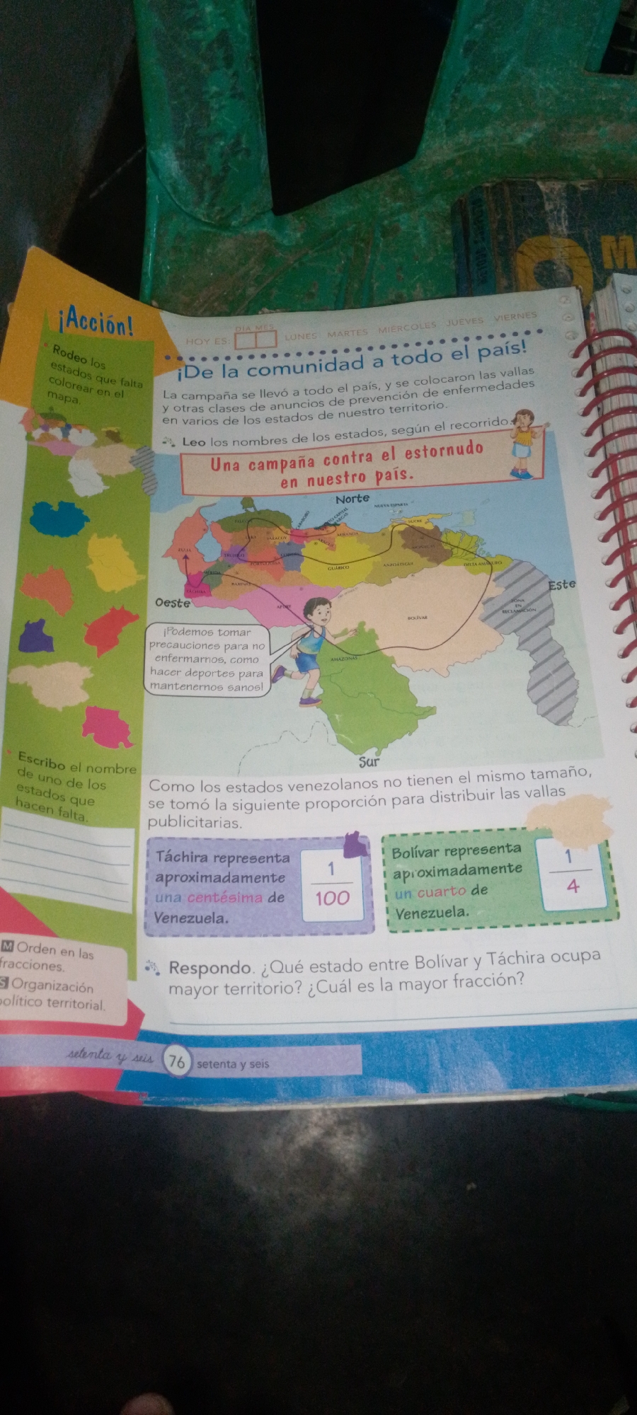
The image is a page from a workbook or educational material featuring a map of Venezuela. The map is colored and shows various states, with some areas highlighted or marked with text. There are also text boxes and instructions on the page. On the left side, there is a section with the title "¡Acción!" (Action!) and bullet points instructing the reader to "Rodeo los estados que falta colorear en el mapa" (Circle the states missing to color on the map). Below this are several uncolored state shapes. The main part of the page displays a map of Venezuela with state borders and names. A line is drawn across the map, possibly indicating a route or campaign path. A small illustration of a child running is placed near the center-left of the map, accompanying a text box that reads: "¡Podemos tomar precauciones para no enfermarnos, como hacer deportes para mantenernos sanos!" (We can take precautions to not get sick, like playing sports to stay healthy!). Above the map, there is text related to a campaign: "¡De la comunidad a todo el país!" (From the community to the whole country!). Further text describes the campaign's reach and purpose. To the right of the map, there are two colored boxes with information about Venezuelan states. One box, colored purple, states "Táchira representa aproximadamente una centésima de Venezuela" (Tachira represents approximately one hundredth of Venezuela), with the fraction 1/100 displayed. Another box, colored green, states "Bolívar representa aproximadamente un cuarto de Venezuela" (Bolivar represents approximately one quarter of Venezuela), with the fraction 1/4 displayed. Below the map, there is a question in Spanish: "Respondo. ¿Qué estado entre Bolívar y Táchira ocupa mayor territorio? ¿Cuál es la mayor fracción?" (I answer. Which state between Bolivar and Tachira occupies the largest territory? Which is the larger fraction?). At the bottom of the page, there is a footer with text that appears to be page numbers or section titles: "setenta y seis" (seventy-six) and a circular number "76". The image does not provide any information or visual cues related to the city of La Tagua, Venezuela. The context is educational and appears to be focused on geography and health awareness. The scene is well-lit, and the materials are laid out flat. There are no people visible besides the small illustration of the child. The environment appears to be indoors, possibly a classroom or home setting, with the
cruzaleja

Jun 12, 2026, 12:27 AM

La Tagua, Venezuela

Moment

Stake attention in this memory

informative
educational
geographical
illustrative
engaging

The image is a page from a workbook or educational material featuring a map of Venezuela. The map is colored and shows various states, with some areas highlighted or marked with text. There are also text boxes and instructions on the page. On the left side, there is a section with the title "¡Acción!" (Action!) and bullet points instructing the reader to "Rodeo los estados que falta colorear en el mapa" (Circle the states missing to color on the map). Below this are several uncolored state shapes. The main part of the page displays a map of Venezuela with state borders and names. A line is drawn across the map, possibly indicating a route or campaign path. A small illustration of a child running is placed near the center-left of the map, accompanying a text box that reads: "¡Podemos tomar precauciones para no enfermarnos, como hacer deportes para mantenernos sanos!" (We can take precautions to not get sick, like playing sports to stay healthy!). Above the map, there is text related to a campaign: "¡De la comunidad a todo el país!" (From the community to the whole country!). Further text describes the campaign's reach and purpose. To the right of the map, there are two colored boxes with information about Venezuelan states. One box, colored purple, states "Táchira representa aproximadamente una centésima de Venezuela" (Tachira represents approximately one hundredth of Venezuela), with the fraction 1/100 displayed. Another box, colored green, states "Bolívar representa aproximadamente un cuarto de Venezuela" (Bolivar represents approximately one quarter of Venezuela), with the fraction 1/4 displayed. Below the map, there is a question in Spanish: "Respondo. ¿Qué estado entre Bolívar y Táchira ocupa mayor territorio? ¿Cuál es la mayor fracción?" (I answer. Which state between Bolivar and Tachira occupies the largest territory? Which is the larger fraction?). At the bottom of the page, there is a footer with text that appears to be page numbers or section titles: "setenta y seis" (seventy-six) and a circular number "76". The image does not provide any information or visual cues related to the city of La Tagua, Venezuela. The context is educational and appears to be focused on geography and health awareness. The scene is well-lit, and the materials are laid out flat. There are no people visible besides the small illustration of the child. The environment appears to be indoors, possibly a classroom or home setting, with the

Symbol

BDB93

Volume

0

Creator

+$0.07

Revenue

+$0.00

TVL

$0.00

1D
1W
1M
All

Loading AttnAds…

transactions
revenues
stakers
Earliest
Latest
Highest stake

1

Alberto Rodríguez

Staked 1mo ago
Redeemed 27d ago

$2.80 USD

+$0.03 USD

Fee: $0.01 (0.25%)

+1.0%

2

Rev Bot 🤖💰

Injected revenue 1mo ago

Revenue bonus for the last stake.

+$0.07 USD

3

Jesús Ferrer

Staked 25d ago
Redeemed 23d ago

$2.80 USD

+$0.00 USD

Fee: $0.01 (0.5%)

+0.1%

4

Rev Bot 🤖💰

Injected revenue 25d ago

Revenue bonus for the last stake.

+$0.05 USD

More from this user

More from La Tagua

cruzaleja

Jun 12, 2026, 12:27 AM

La Tagua, Venezuela

Licensed under Creative Commons Attribution 4.0 International License. You are free to share and adapt this content with proper attribution.