Stake attention in this memory
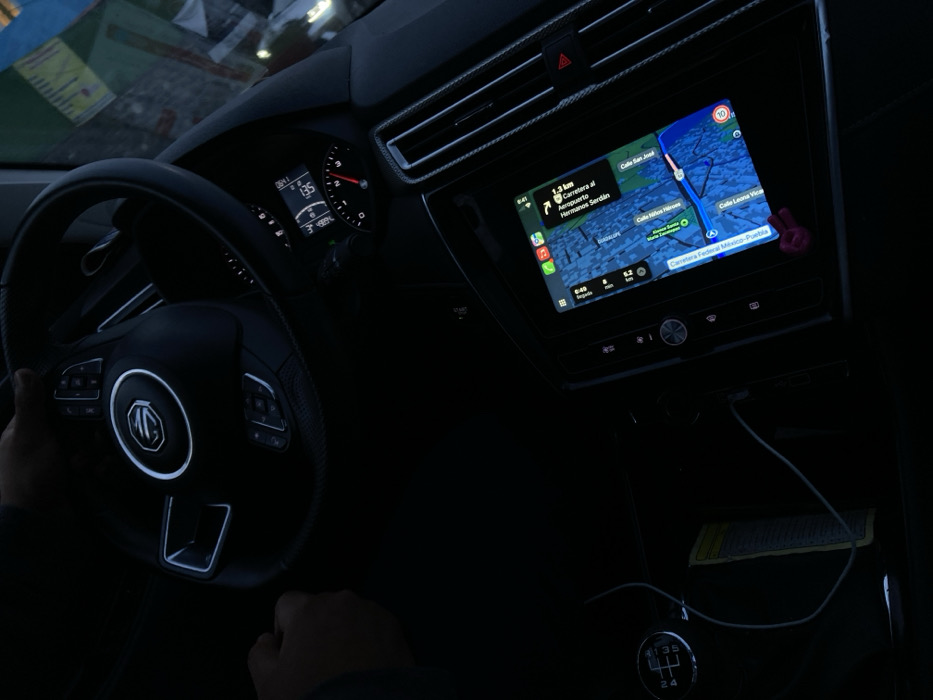
The image captures the interior of a vehicle from a high-angle perspective, facing forward towards the dashboard and windshield. The scene is dimly lit, suggesting dusk or night conditions. Two hands belonging to a driver are visible: one is gripping the black multi-function steering wheel, which features a prominent chrome MG logo at its center and illuminated control buttons. The other hand rests near the manual gear shift lever, which displays a "1 2 3 4 5 R" pattern. The dashboard's instrument cluster, partially obscured by the steering wheel, displays a digital reading of "136" (likely km/h) for speed, a fuel gauge, and the time "1:01". A central infotainment touchscreen is active, displaying a navigation application, consistent with Apple Maps, featuring a blue route line. The map indicates the vehicle's current position on "Carretera Federal Mexico-Puebla." Visible points of interest and road names include "Calle Niños Heroes," "Calle San José," "Calle Leona Vicario," and a route segment leading to "Carrera al Aeropuerto Hnos Serdan" (Road to Hermanos Serdán Airport). The screen also shows the time "9:41" in its upper left corner. A small, pink peace-sign shaped charm is attached to the bottom edge of the screen. To the right of the infotainment screen are vertical air vents, separated by a red hazard warning light button. A white charging cable is connected to a port below the screen, extending towards a compartment where a rectangular yellow-white card or paper is visible. Through the windshield, blurred reflections of brightly colored objects and indistinct light sources are visible, suggesting an external urban or semi-urban setting. Based on the navigation system's explicit display of "Carretera Federal Mexico-Puebla" and "Carrera al Aeropuerto Hnos Serdan," the vehicle is located on Federal Highway Mexico-Puebla, within the approximate vicinity of Santa María Zacatepec, Puebla, Mexico, and is actively navigating towards the Hermanos Serdán International Airport.
No transactions found