
Sign in
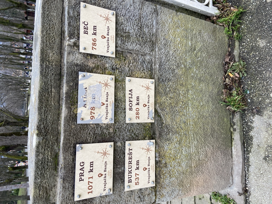
The image displays a weathered, rough-hewn stone pillar or monument with five rectangular plaques affixed to its side. The stone structure itself appears to be made of grey, textured material, possibly granite, and shows signs of outdoor exposure with some moss or discoloration in parts. To the right of the monument, there is a patch of green grass mixed with dry leaves and dirt, bordering a darker grey asphalt or concrete path. In the blurred background, bare trees suggest an outdoor setting, possibly a park or an avenue, with faint outlines of what might be buildings or more distant landscape features. The lighting indicates it is daytime.

Each of the five visible plaques is light-colored, possibly beige or off-white, and features a decorative compass rose design along with a subtle, aged map-like texture in the background. The text on all plaques is in a dark brown color. Each plaque follows a consistent format: a city name at the top, a distance in kilometers, and below that, "Vrnjačka Banja" accompanied by a location pin icon, indicating that Vrnjačka Banja is the reference point for all listed distances.

The visible plaques and their details are:

1.  **Top Right Plaque:**
    *   Text: "BEČ" (Vienna)
    *   Distance: "786 km"
    *   Reference Point: "Vrnjačka Banja"

2.  **Middle Left Plaque (partially obscured and worn):**
    *   Text: "ATINA" (Athens - *corrected from OCR "Alina" based on visual inspection*)
    *   Distance: "978 km"
    *   Reference Point: "Vrnjačka Banja"

3.  **Middle Right Plaque:**
    *   Text: "SOFIJA" (Sofia)
    *   Distance: "280 km"
    *   Reference Point: "Vrnjačka Banja"

4.  **Bottom Left Plaque:**
    *   Text: "PRAG" (Prague)
    *   Distance: "1071 km"
    *   Reference Point: "Vrnjačka Banja"

5.  **Bottom Right Plaque:**
    *   Text: "BUKUREŠT" (Bucharest)
    *   Distance: "537 km"
    *   Reference Point: "Vrnjačka Banja"

The image captures an informational monument, likely intended for tourists or visitors, showcasing the distances from Vrnjačka Banja to several prominent European cities. The overall impression is one of a local landmark in an urban or park setting during what appears to be a cooler season due to the bare trees.
du-fa

Feb 16, 2026, 3:24 PM

Vrnjacka Banja Municipality, Serbia

Stake attention in this memory

distance markers
city signs
monument
travel
destinations

The image displays a weathered, rough-hewn stone pillar or monument with five rectangular plaques affixed to its side. The stone structure itself appears to be made of grey, textured material, possibly granite, and shows signs of outdoor exposure with some moss or discoloration in parts. To the right of the monument, there is a patch of green grass mixed with dry leaves and dirt, bordering a darker grey asphalt or concrete path. In the blurred background, bare trees suggest an outdoor setting, possibly a park or an avenue, with faint outlines of what might be buildings or more distant landscape features. The lighting indicates it is daytime. Each of the five visible plaques is light-colored, possibly beige or off-white, and features a decorative compass rose design along with a subtle, aged map-like texture in the background. The text on all plaques is in a dark brown color. Each plaque follows a consistent format: a city name at the top, a distance in kilometers, and below that, "Vrnjačka Banja" accompanied by a location pin icon, indicating that Vrnjačka Banja is the reference point for all listed distances. The visible plaques and their details are: 1. **Top Right Plaque:** * Text: "BEČ" (Vienna) * Distance: "786 km" * Reference Point: "Vrnjačka Banja" 2. **Middle Left Plaque (partially obscured and worn):** * Text: "ATINA" (Athens - *corrected from OCR "Alina" based on visual inspection*) * Distance: "978 km" * Reference Point: "Vrnjačka Banja" 3. **Middle Right Plaque:** * Text: "SOFIJA" (Sofia) * Distance: "280 km" * Reference Point: "Vrnjačka Banja" 4. **Bottom Left Plaque:** * Text: "PRAG" (Prague) * Distance: "1071 km" * Reference Point: "Vrnjačka Banja" 5. **Bottom Right Plaque:** * Text: "BUKUREŠT" (Bucharest) * Distance: "537 km" * Reference Point: "Vrnjačka Banja" The image captures an informational monument, likely intended for tourists or visitors, showcasing the distances from Vrnjačka Banja to several prominent European cities. The overall impression is one of a local landmark in an urban or park setting during what appears to be a cooler season due to the bare trees.

Loading AttnAds…

transactions
revenues
stakers
Earliest
Latest
Highest stake

No transactions found

More from this user

More from Vrnjacka Banja Municipality

du-fa

Feb 16, 2026, 3:24 PM

Vrnjacka Banja Municipality, Serbia

Licensed under Creative Commons Attribution 4.0 International License. You are free to share and adapt this content with proper attribution.