Sign in
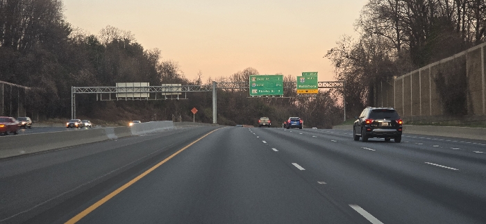
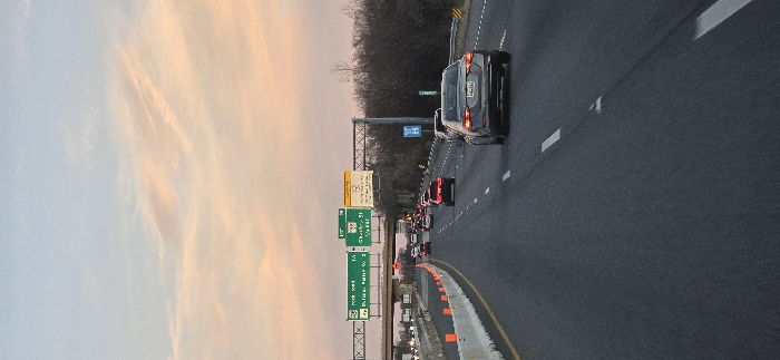
The image, captured in a portrait orientation, displays a highway scene at what appears to be either dawn or dusk. The left side of the frame is dominated by the sky, which transitions from light blue at the bottom left to warm peach and orange hues towards the top right, featuring wispy clouds.

The right side of the image features a multi-lane asphalt highway, with vehicles traveling generally upwards towards the top of the frame. In the immediate foreground, a dark-colored sedan, likely grey or black, is seen from the rear in the rightmost lane. Its brake lights are off, and a partially visible Maryland license plate is affixed. Orange traffic cones line the right edge of the road, bordering a concrete barrier.

Further up the highway, numerous other vehicles are present in multiple lanes, suggesting traffic congestion, with some cars displaying illuminated brake lights. Overhead gantries stretch across the road, supporting several green highway signs. Visible text on these signs includes "EXIT 27 SOUTH I-83 Balt. - S. Pk.", "EXIT 28 TO MD 140 Shawan Rd.", and "EXIT 28B W. PADONIA RD. Cockeysville". A smaller sign on the gantry also reads "27A MD 127 Dulaney Valley Rd.". A blue sign with the "MDTA" (Maryland Transportation Authority) logo is also seen further along the road.

Beyond the highway infrastructure, a line of bare, leafless trees crests an embankment or hill, silhouetted against the vibrant sky. The specific highway and road names like I-83, Baltimore, Shawan Road, Dulaney Valley Road, and Cockeysville, combined with the Maryland license plate and MDTA logo, pinpoint the location as the vicinity of Towson, Maryland, United States. The scene depicts active highway commuting, likely during a busy hour.
F
FM-GSsNt2

Dec 8, 2024, 9:43 PM

Towson, USA

Stake attention in this memory

The image, captured in a portrait orientation, displays a highway scene at what appears to be either dawn or dusk. The left side of the frame is dominated by the sky, which transitions from light blue at the bottom left to warm peach and orange hues towards the top right, featuring wispy clouds. The right side of the image features a multi-lane asphalt highway, with vehicles traveling generally upwards towards the top of the frame. In the immediate foreground, a dark-colored sedan, likely grey or black, is seen from the rear in the rightmost lane. Its brake lights are off, and a partially visible Maryland license plate is affixed. Orange traffic cones line the right edge of the road, bordering a concrete barrier. Further up the highway, numerous other vehicles are present in multiple lanes, suggesting traffic congestion, with some cars displaying illuminated brake lights. Overhead gantries stretch across the road, supporting several green highway signs. Visible text on these signs includes "EXIT 27 SOUTH I-83 Balt. - S. Pk.", "EXIT 28 TO MD 140 Shawan Rd.", and "EXIT 28B W. PADONIA RD. Cockeysville". A smaller sign on the gantry also reads "27A MD 127 Dulaney Valley Rd.". A blue sign with the "MDTA" (Maryland Transportation Authority) logo is also seen further along the road. Beyond the highway infrastructure, a line of bare, leafless trees crests an embankment or hill, silhouetted against the vibrant sky. The specific highway and road names like I-83, Baltimore, Shawan Road, Dulaney Valley Road, and Cockeysville, combined with the Maryland license plate and MDTA logo, pinpoint the location as the vicinity of Towson, Maryland, United States. The scene depicts active highway commuting, likely during a busy hour.

Loading AttnAds…

transactions
revenues
stakers
Earliest
Latest
Highest stake

No transactions found

More from this user

More from Towson

FFM-GSsNt2

Dec 8, 2024, 9:43 PM

Towson, USA

Licensed under Creative Commons Attribution 4.0 International License. You are free to share and adapt this content with proper attribution.