Stake attention in this memory
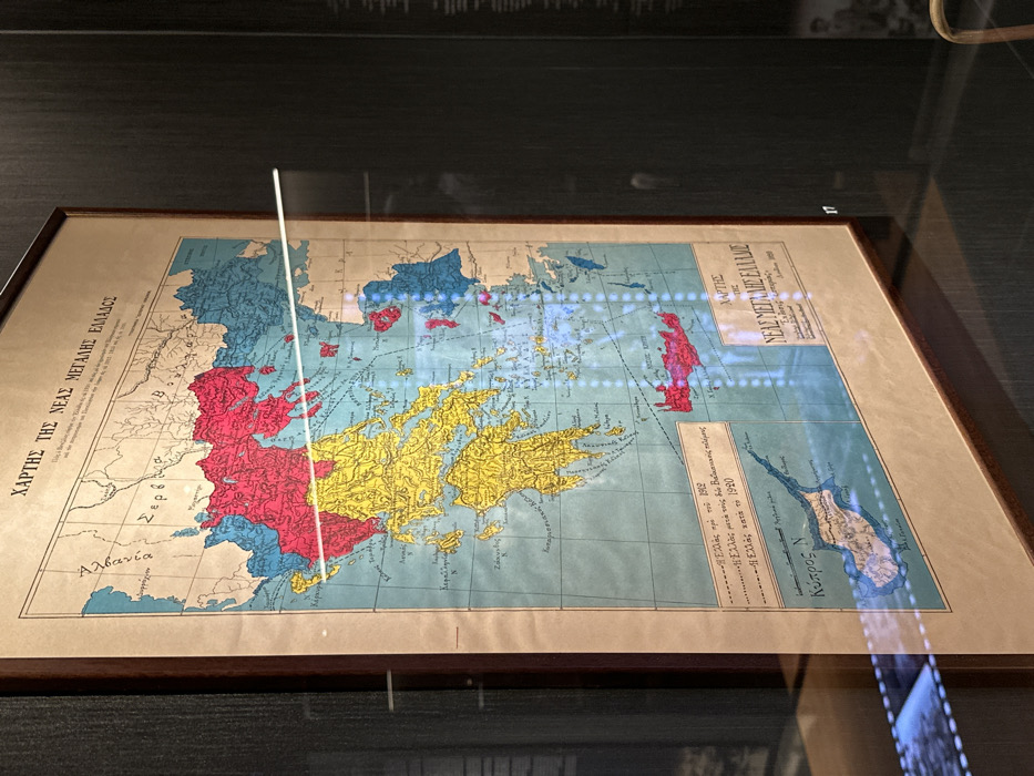
This media file captures a framed historical map, titled "ΧΑΡΤΗΣ ΤΗΣ ΝΕΑΣ ΜΕΓΑΛΗΣ ΕΛΛΑΔΟΣ" (Map of the New Greater Greece), displayed under a protective glass surface. The map depicts the Balkan peninsula and surrounding regions, highlighting territorial changes related to Greece. Visible text on the map's title also includes "Εκδοσις εσπερίας" (Esperos Edition). A legend in the lower right corner uses different colors to represent Greece at various historical junctures: * The area labeled "—Ελλάς προ του 1912" (Greece before 1912) is not explicitly colored in the legend but can be inferred from the map. * "—Η Ελλάς μετά τους δύο Βαλκανικούς πολέμους" (Greece after the two Balkan Wars) * "—Η Ελλάς κατά το 1920" (Greece in 1920) The map uses distinct colors for different regions: red, yellow, blue, and a lighter blue or grey. Notable geographical names visible include "Αλβανία" (Albania), "Σερβ" (likely part of Serbia), and "Κύπρος Ν" (Cyprus N). The map is housed in a dark brown frame and is displayed in what appears to be a museum or exhibition setting, possibly in Nea Filadelfia, Greece, given the context. The glass covering the map reflects overhead lights, appearing as bright blue and white streaks, as well as a vertical white line, possibly from an external light source or part of the display case. A reflection of what looks like a film strip or digital screen is also visible on the lower right portion of the glass. A small white label with the number "17" is positioned in the upper right corner of the map itself. The scene is brightly lit, showcasing the details of the historical document.
No transactions found