Sign in
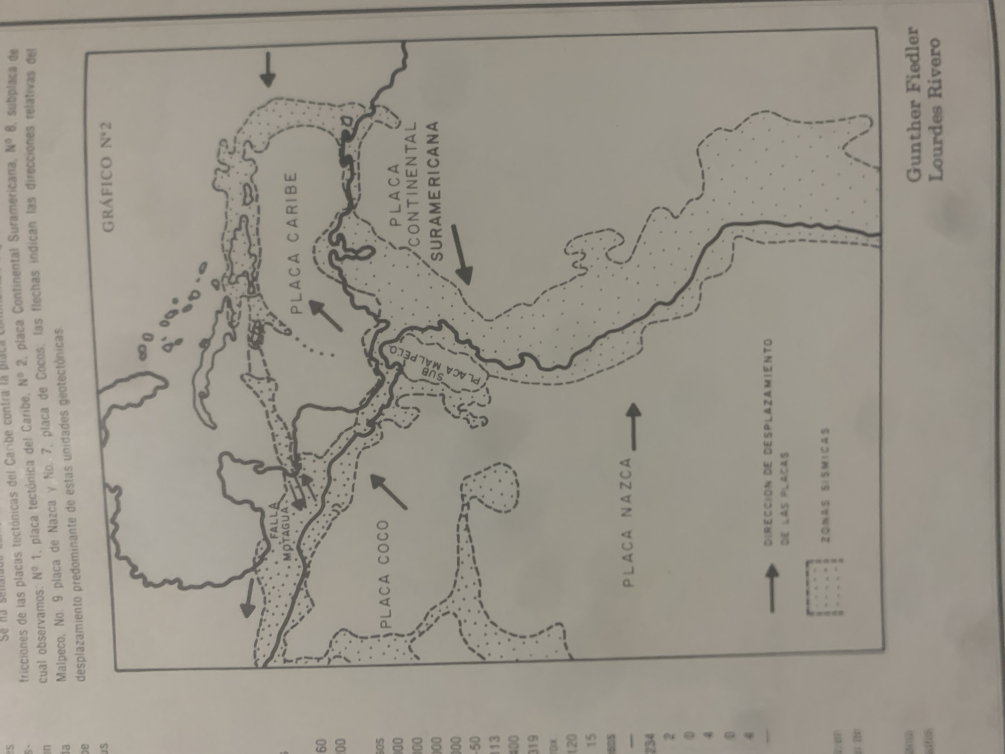
This is a scanned image of a geological map detailing tectonic plate boundaries and movements in a region that includes Central America and the northern coast of South America. The map is oriented vertically and displays the Caribbean Plate, Cocos Plate, Nazca Plate, and the Continental South American Plate, along with sub-plates like Malpelo. Arrows indicate the direction of plate displacement, and areas are demarcated with different line styles and stippling, likely representing different geological features or zones.

Visible text includes labels for the tectonic plates, fault lines (e.g., "FALLA MOTAGUA"), and directional information ("DIRECCION DE DESPLAZAMIENTO DE LAS PLACAS"). There is also a title "GRÁFICO N°2" and a legend or key that lists numbers and potentially some values related to seismic zones or plate interactions. At the bottom right, the names "Gunther Fiedler" and "Lourdes Rivero" appear, suggesting they are the authors or researchers associated with this map. The text at the top provides a descriptive caption about the tectonic plates and their relative directions of movement.

The image appears to be from a publication or academic paper, given the presence of authors' names and the detailed, scientific nature of the map. The lighting suggests it was photographed indoors, likely under artificial light, with some slight glare visible. The overall impression is that of a technical diagram used to illustrate geological concepts.
bombolico

Jun 25, 2026, 2:04 PM

La Tagua, Venezuela

Moment

Stake attention in this memory

informative
scientific
analytical
educational
geological

This is a scanned image of a geological map detailing tectonic plate boundaries and movements in a region that includes Central America and the northern coast of South America. The map is oriented vertically and displays the Caribbean Plate, Cocos Plate, Nazca Plate, and the Continental South American Plate, along with sub-plates like Malpelo. Arrows indicate the direction of plate displacement, and areas are demarcated with different line styles and stippling, likely representing different geological features or zones. Visible text includes labels for the tectonic plates, fault lines (e.g., "FALLA MOTAGUA"), and directional information ("DIRECCION DE DESPLAZAMIENTO DE LAS PLACAS"). There is also a title "GRÁFICO N°2" and a legend or key that lists numbers and potentially some values related to seismic zones or plate interactions. At the bottom right, the names "Gunther Fiedler" and "Lourdes Rivero" appear, suggesting they are the authors or researchers associated with this map. The text at the top provides a descriptive caption about the tectonic plates and their relative directions of movement. The image appears to be from a publication or academic paper, given the presence of authors' names and the detailed, scientific nature of the map. The lighting suggests it was photographed indoors, likely under artificial light, with some slight glare visible. The overall impression is that of a technical diagram used to illustrate geological concepts.

Symbol

D97E8

Volume

0

Creator

+$0.08

Revenue

+$0.00

TVL

$0.00

1D
1W
1M
All

Loading AttnAds…

transactions
revenues
stakers
Earliest
Latest
Highest stake

1

Ramón

Staked 12d ago
Redeemed 8d ago

$6.63 USD

+$0.03 USD

Fee: $0.02 (0.25%)

+0.5%

2

Rev Bot 🤖💰

Injected revenue 12d ago

Revenue bonus for the last stake.

+$0.13 USD

More from this user

More from La Tagua

bombolico

Jun 25, 2026, 2:04 PM

La Tagua, Venezuela

Licensed under Creative Commons Attribution 4.0 International License. You are free to share and adapt this content with proper attribution.





