Sign in
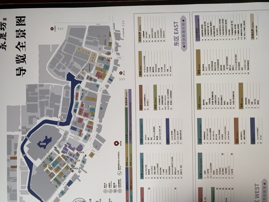
The image displays a detailed, large-format guide map of a commercial and cultural complex named "永慶坊" (Yongqingfang). The map is presented on a vertical board, likely mounted indoors. It illustrates the layout of the area, featuring a prominent waterway or canal running through the center, which divides the complex into multiple sections. Various buildings are depicted with distinct shapes, color-coded, and labeled with numbers.

The map is structured into "东区 EAST" (East District) and "西区 WEST" (West District), as indicated by prominent headings. Adjacent panels list numerous establishments, categorized by type, corresponding to the color-coding and numbers on the map. These categories include "国潮品牌 Fashion" (National Tide Brand Fashion), "零售 Retail," "轻餐 Beverage & sweet" (Light Meal Beverage & Sweet), "体验 Observe" (Experience/Observe), and "服务 Service." Specific cultural areas like "永庆坊美食街区" (Yongqingfang Food Street Honored Brand) and "广州非遗街区 Guangzhou Intangible Cultural Heritage" are also highlighted.

Key visible text includes the map's title, "永慶坊 导览全景图" (Yongqingfang Guide Map), and a "服务热线: 020-81008663" (Service Hotline). Directional arrows point towards "上下九步行街" (Shangxiajiu Pedestrian Street). Small symbols on the map indicate practical amenities such as a medical point, nursery room, police station, self-service information point, and public restrooms. No people are visible in the image, and the time of day cannot be determined. The map serves as a directory for visitors navigating the Yongqingfang area in Guangzhou, China.
F
FM-CaIMM2

Jan 4, 2025, 8:02 AM

Guang Zhou Shi, China

Stake attention in this memory

The image displays a detailed, large-format guide map of a commercial and cultural complex named "永慶坊" (Yongqingfang). The map is presented on a vertical board, likely mounted indoors. It illustrates the layout of the area, featuring a prominent waterway or canal running through the center, which divides the complex into multiple sections. Various buildings are depicted with distinct shapes, color-coded, and labeled with numbers. The map is structured into "东区 EAST" (East District) and "西区 WEST" (West District), as indicated by prominent headings. Adjacent panels list numerous establishments, categorized by type, corresponding to the color-coding and numbers on the map. These categories include "国潮品牌 Fashion" (National Tide Brand Fashion), "零售 Retail," "轻餐 Beverage & sweet" (Light Meal Beverage & Sweet), "体验 Observe" (Experience/Observe), and "服务 Service." Specific cultural areas like "永庆坊美食街区" (Yongqingfang Food Street Honored Brand) and "广州非遗街区 Guangzhou Intangible Cultural Heritage" are also highlighted. Key visible text includes the map's title, "永慶坊 导览全景图" (Yongqingfang Guide Map), and a "服务热线: 020-81008663" (Service Hotline). Directional arrows point towards "上下九步行街" (Shangxiajiu Pedestrian Street). Small symbols on the map indicate practical amenities such as a medical point, nursery room, police station, self-service information point, and public restrooms. No people are visible in the image, and the time of day cannot be determined. The map serves as a directory for visitors navigating the Yongqingfang area in Guangzhou, China.

Loading AttnAds…

transactions
revenues
stakers
Earliest
Latest
Highest stake

No transactions found

More from this user

More from Guang Zhou Shi

FFM-CaIMM2

Jan 4, 2025, 8:02 AM

Guang Zhou Shi, China

Licensed under Creative Commons Attribution 4.0 International License. You are free to share and adapt this content with proper attribution.