
Sign in
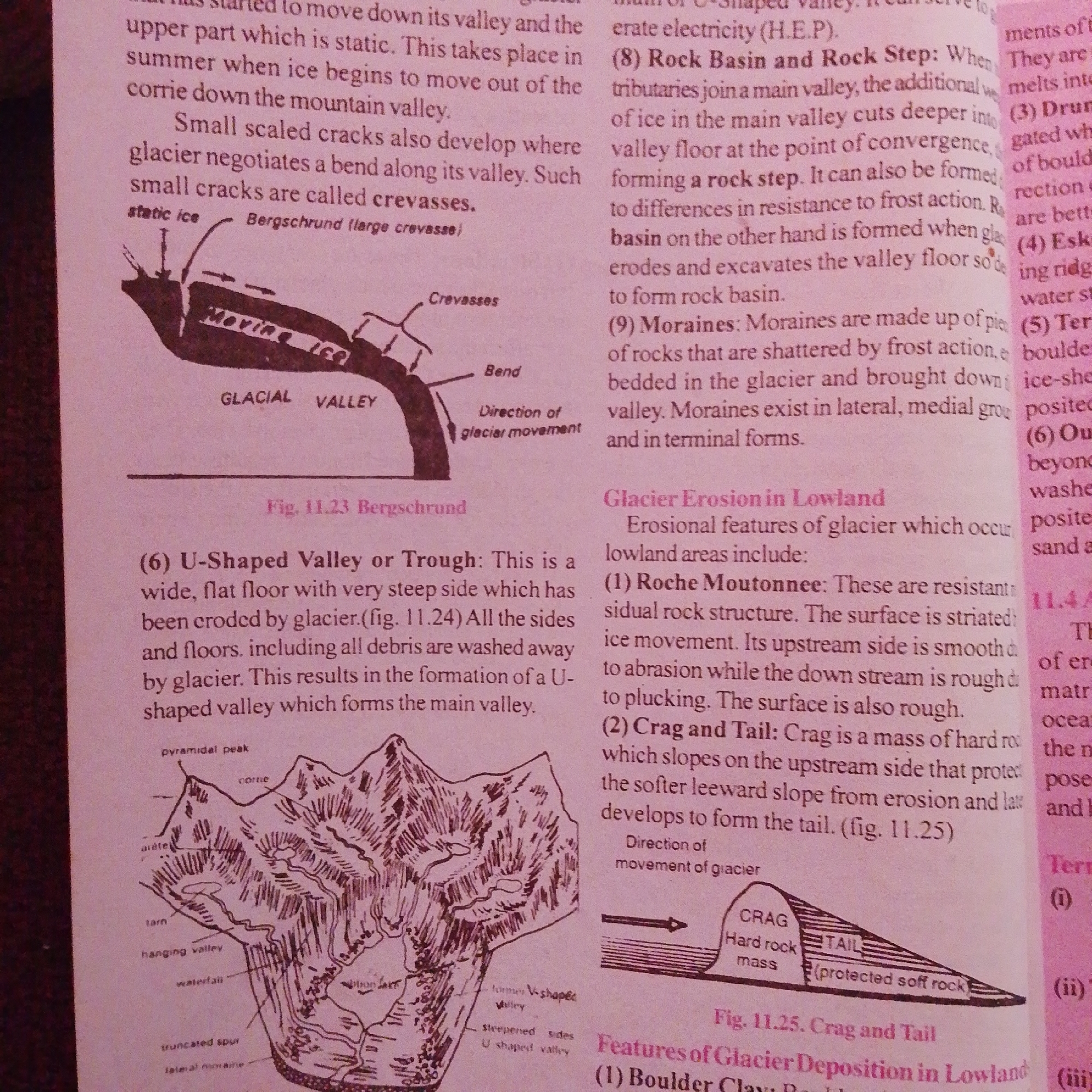
This is a scanned page from a textbook or educational material, likely discussing glaciers and their geological impact. The page features a combination of text and illustrations.

The main subjects are educational diagrams and their accompanying explanations. The diagrams depict various glacial landforms and processes:
- A cross-section of a glacial valley, showing features like "static ice," "moving ice," "crevasses," and a "bergschrund."
- A detailed illustration of a glaciated mountain landscape, labeled with features such as "pyramidal peak," "arête," "cirque," "tarn," "hanging valley," "waterfall," and "truncated spur."
- A diagram illustrating the "Crag and Tail" feature, with labels for "CRAG," "Hard rock mass," and "TAIL (protected soft rock)."

The text discusses topics such as U-shaped valleys, glacier erosion in lowland areas, and features like Roche Moutonnee, Crag and Tail, and Boulder Clay. Specific numbered points, like (6) U-Shaped Valley, (8) Rock Basin and Rock Step, and (9) Moraines, break down the information.

There is no indication of people, specific time of day, weather, or emotions as this is purely an informational illustration. The location context of Jalingo, Nigeria, is not visually represented or mentioned in the visible text; this context appears to be external information provided to the AI. The text is in English.
FM-66btC3

Jun 30, 2026, 4:06 PM

Jalingo, Nigeria

Moment

Stake attention in this memory

curious
studious
analytical
calm
focused

This is a scanned page from a textbook or educational material, likely discussing glaciers and their geological impact. The page features a combination of text and illustrations. The main subjects are educational diagrams and their accompanying explanations. The diagrams depict various glacial landforms and processes: - A cross-section of a glacial valley, showing features like "static ice," "moving ice," "crevasses," and a "bergschrund." - A detailed illustration of a glaciated mountain landscape, labeled with features such as "pyramidal peak," "arête," "cirque," "tarn," "hanging valley," "waterfall," and "truncated spur." - A diagram illustrating the "Crag and Tail" feature, with labels for "CRAG," "Hard rock mass," and "TAIL (protected soft rock)." The text discusses topics such as U-shaped valleys, glacier erosion in lowland areas, and features like Roche Moutonnee, Crag and Tail, and Boulder Clay. Specific numbered points, like (6) U-Shaped Valley, (8) Rock Basin and Rock Step, and (9) Moraines, break down the information. There is no indication of people, specific time of day, weather, or emotions as this is purely an informational illustration. The location context of Jalingo, Nigeria, is not visually represented or mentioned in the visible text; this context appears to be external information provided to the AI. The text is in English.

Symbol

E89E0

Volume

2,691

Creator

+$0.00

Revenue

+$0.00

TVL

$0.19

1D
1W
1M
All

Loading AttnAds…

transactions
revenues
stakers
Earliest
Latest
Highest stake

1

FM-mmBz23

Staked 1mo ago

$0.19 USD

+$0.00 USD

+1%

2

Rev Bot 🤖💰

Injected revenue 1mo ago

Revenue bonus for the last stake.

+$0.00 USD

More from this user

More from Jalingo

FM-66btC3

Jun 30, 2026, 4:06 PM

Jalingo, Nigeria

Licensed under Creative Commons Attribution 4.0 International License. You are free to share and adapt this content with proper attribution.