Sign in
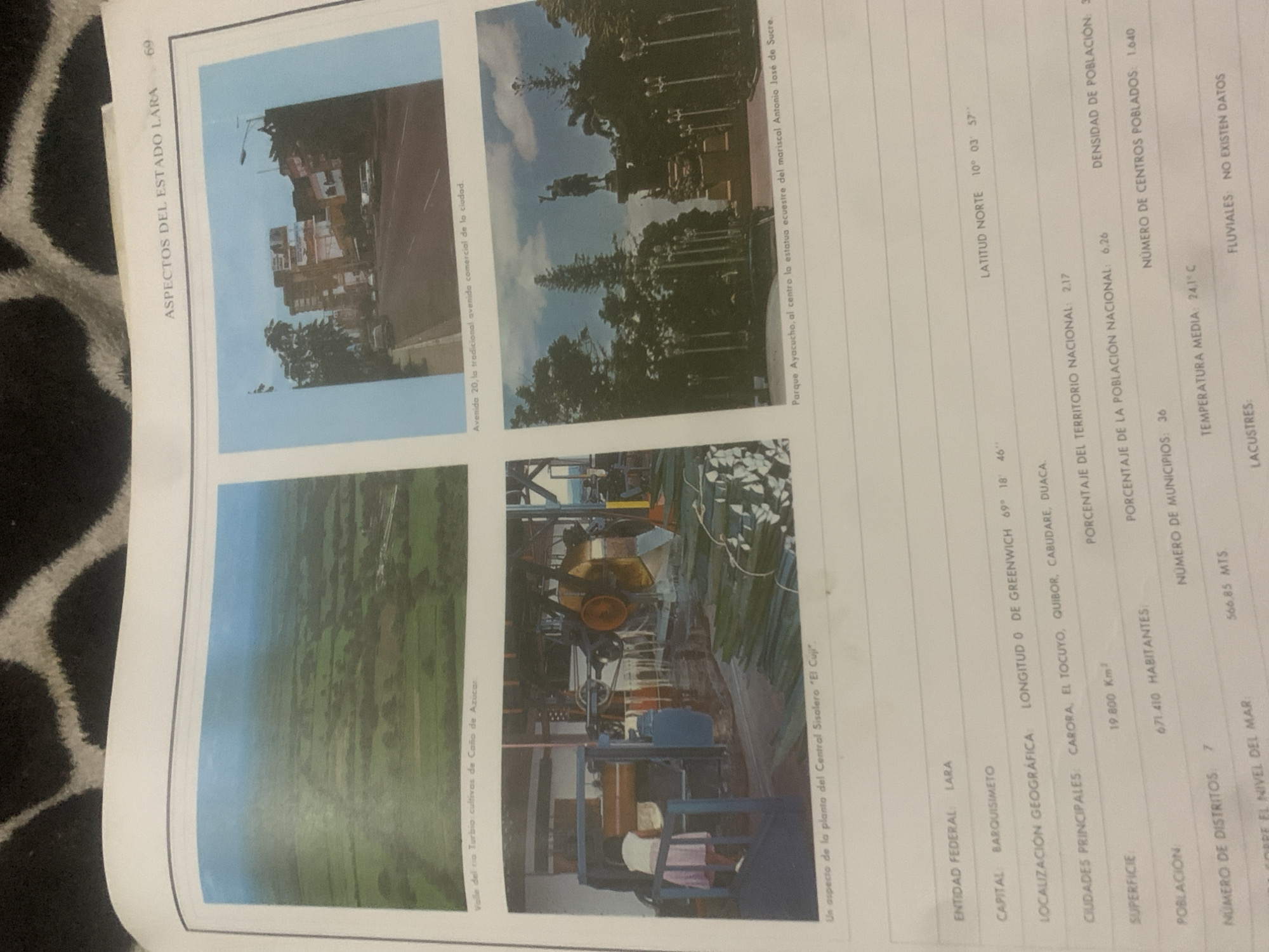
This media file presents a collection of photographs and accompanying text, likely from a book or document, detailing aspects of the state of Lara in Venezuela. The content is divided into four images.

The top left image shows a street scene in a city, featuring buildings, a lamppost, and trees along a road. The caption beneath it identifies it as "Avenida 20, la tradicional avenida comercial de la ciudad."

The top right image depicts a park with a statue of a person on horseback, surrounded by trees. The caption states this is "Parque Ayacucho, al centro la estatua ecuestre del mariscal Antonio José de Sucre."

The bottom left image offers an aerial view of a landscape, characterized by green fields, suggesting agricultural use, with the caption "Valle del rio Turbio: cultivas de Caño de Azúcar."

The bottom right image focuses on an industrial setting, showing machinery, possibly related to sugar processing, with the caption "Un aspecto de la planta del Central Sisalero 'El Cuji'."

The text on the right side provides statistical data related to the state of Lara, including its entity, capital (Barquisimeto), geographical location (latitude and longitude), principal cities, surface area, population, number of municipalities, and temperature. It also notes the number of districts and mentions "fluvales" with "no existen datos," implying data on rivers is unavailable. A specific elevation is also mentioned: "566.85 MTS." and "RE EL NIVEL DEL MAR".
bombolico

Jun 25, 2026, 2:26 PM

La Tagua, Venezuela

Short Term

Stake attention in this memory

nostalgic
educational
informative
observational
sentimental

This media file presents a collection of photographs and accompanying text, likely from a book or document, detailing aspects of the state of Lara in Venezuela. The content is divided into four images. The top left image shows a street scene in a city, featuring buildings, a lamppost, and trees along a road. The caption beneath it identifies it as "Avenida 20, la tradicional avenida comercial de la ciudad." The top right image depicts a park with a statue of a person on horseback, surrounded by trees. The caption states this is "Parque Ayacucho, al centro la estatua ecuestre del mariscal Antonio José de Sucre." The bottom left image offers an aerial view of a landscape, characterized by green fields, suggesting agricultural use, with the caption "Valle del rio Turbio: cultivas de Caño de Azúcar." The bottom right image focuses on an industrial setting, showing machinery, possibly related to sugar processing, with the caption "Un aspecto de la planta del Central Sisalero 'El Cuji'." The text on the right side provides statistical data related to the state of Lara, including its entity, capital (Barquisimeto), geographical location (latitude and longitude), principal cities, surface area, population, number of municipalities, and temperature. It also notes the number of districts and mentions "fluvales" with "no existen datos," implying data on rivers is unavailable. A specific elevation is also mentioned: "566.85 MTS." and "RE EL NIVEL DEL MAR".

Symbol

E8B67

Volume

11,550

Creator

+$0.09

Revenue

+$0.12

TVL

$7.27

1D
1W
1M
All

Loading AttnAds…

transactions
revenues
stakers
Earliest
Latest
Highest stake

1

Katy

Staked 10d ago

$7.22 USD

+$0.05 USD

+0.7%

2

Rev Bot 🤖💰

Injected revenue 10d ago

Revenue bonus for the last stake.

+$0.14 USD

More from this user

More from La Tagua

bombolico

Jun 25, 2026, 2:26 PM

La Tagua, Venezuela

Licensed under Creative Commons Attribution 4.0 International License. You are free to share and adapt this content with proper attribution.





