Oct 14, 2025
Stake attention in this memory
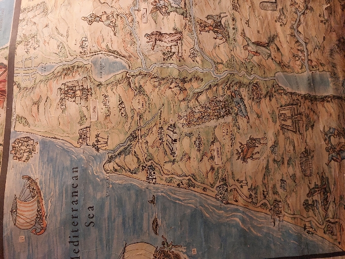
This image displays an aged, illustrated map depicting the historical Levant region, encompassing the land between the Mediterranean Sea and the Jordan River valley. The physical location of the map itself is unknown. The map, rendered in an antique style with warm, earthy tones, features the "Mediterranean Sea" prominently on the left, labeled in English. Several ancient-style sailing vessels are shown on the sea, including a large galley with a striped sail and oars in the upper left, and parts of another ship at the lower left. A large marine creature, possibly a whale, is also depicted in the sea. Inland, the topography shows a coastal plain rising to hills and mountains, with rivers flowing towards the "Lake Genereth" (Sea of Galilee) in the upper-right central portion and the "Dead Sea" or "Salt Sea" further south. Numerous stylized ancient cities and settlements are scattered across the landscape. Some are labeled in Hebrew, such as "Jaffa" (יפו) on the coast, "Samaria" (שומרון) inland, and "Jerusalem" (ירושלם) partially visible towards the upper right. The map is populated with various figures and scenes, likely illustrating biblical events. These include: * A figure riding a donkey-like animal, transporting a rectangular chest, possibly the Ark of the Covenant. * A large figure with a spear, possibly Goliath, next to a smaller figure. * A man kneeling with outstretched arms on a hill, facing two stone tablets (the Decalogue) on a nearby peak. * Groups of people engaged in various activities, such as battle or daily life. * Structures resembling altars, temples, or fortified encampments. * Agricultural scenes with animals, such as sheep. * A river system, likely representing the Jordan River, connecting the two major inland bodies of water. The overall environment is presented as a diverse landscape of coastal plains, fertile valleys, and arid mountainous regions. The illustrative style includes a mix of detailed geographical features and narrative vignettes.
No transactions found
More from this user