
Sign in
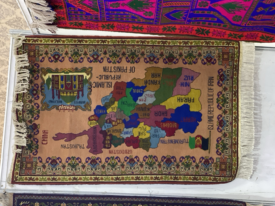
A rectangular, light brown rug, likely depicting a map of Afghanistan and its surrounding regions, is prominently displayed, possibly in a market or shop in Kandahar, Afghanistan. The rug is adorned with a decorative border featuring intricate floral and geometric patterns in shades of green, red, brown, and gold. Its fringes are visible on the left and right sides.

The central design of the rug is a colorful map, with different provinces of Afghanistan rendered in various hues such as green, blue, yellow, red, orange, and brown. Visible provinces include "KANDA HAR", "FARAH", "HERAT", "GHOR DAI", "ZABUL", "KUNDUZ", "BADAKHSHAN", "NIM-RUZ", "BALKH", "BAGHLAN", "PAN", "NUR", "LUG", and "NANGARHAR". Neighboring countries are also labeled: "CHINA", "TAJIKISTAN", "UZBEKISTAN", "TURKMENISTAN", "ISLAMIC REPUBLIC OF IRAN", and "ISLAMIC REPUBLIC OF PAKISTAN". A small flag of Afghanistan is depicted on the map near Turkmenistan.

In the upper-left quadrant of the map, an illustration of a building, possibly a historical monument or mosque, is featured, accompanied by text that includes "NIKE JAND" and "MIRWAY'S" in English, and words like "میرامیس" and "نیکه‌کان" in a script likely Dari or Pashto.

Partially visible above the main rug is another textile, possibly a second rug, with vibrant purple and red colors and abstract or geometric patterns. The overall scene suggests a display of handcrafted textiles, characteristic of the region. The rugs are oriented diagonally within the frame.
Wahid_Rahman_Afghanmal

Nov 12, 2025, 7:07 AM

Kandahar, Afghanistan

Stake attention in this memory

carpet
Afghanistan
map
textile
handicraft

A rectangular, light brown rug, likely depicting a map of Afghanistan and its surrounding regions, is prominently displayed, possibly in a market or shop in Kandahar, Afghanistan. The rug is adorned with a decorative border featuring intricate floral and geometric patterns in shades of green, red, brown, and gold. Its fringes are visible on the left and right sides. The central design of the rug is a colorful map, with different provinces of Afghanistan rendered in various hues such as green, blue, yellow, red, orange, and brown. Visible provinces include "KANDA HAR", "FARAH", "HERAT", "GHOR DAI", "ZABUL", "KUNDUZ", "BADAKHSHAN", "NIM-RUZ", "BALKH", "BAGHLAN", "PAN", "NUR", "LUG", and "NANGARHAR". Neighboring countries are also labeled: "CHINA", "TAJIKISTAN", "UZBEKISTAN", "TURKMENISTAN", "ISLAMIC REPUBLIC OF IRAN", and "ISLAMIC REPUBLIC OF PAKISTAN". A small flag of Afghanistan is depicted on the map near Turkmenistan. In the upper-left quadrant of the map, an illustration of a building, possibly a historical monument or mosque, is featured, accompanied by text that includes "NIKE JAND" and "MIRWAY'S" in English, and words like "میرامیس" and "نیکه‌کان" in a script likely Dari or Pashto. Partially visible above the main rug is another textile, possibly a second rug, with vibrant purple and red colors and abstract or geometric patterns. The overall scene suggests a display of handcrafted textiles, characteristic of the region. The rugs are oriented diagonally within the frame.

Loading AttnAds…

transactions
revenues
stakers
Earliest
Latest
Highest stake

No transactions found

More from this user

More from Kandahar

Wahid_Rahman_Afghanmal

Nov 12, 2025, 7:07 AM

Kandahar, Afghanistan

Licensed under Creative Commons Attribution 4.0 International License. You are free to share and adapt this content with proper attribution.