Sign in
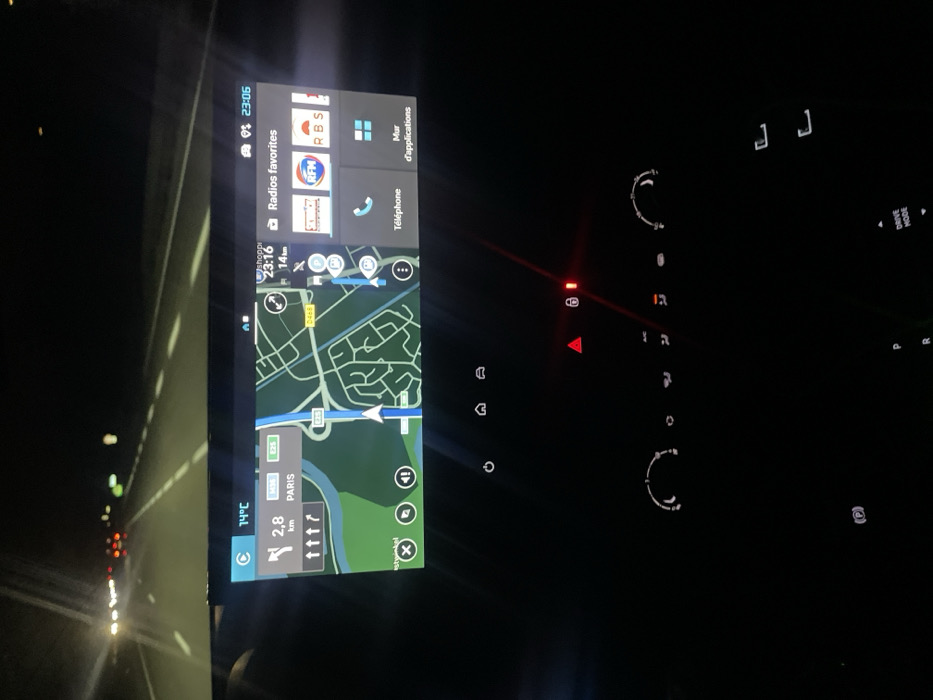
The image displays the interior of a vehicle at night, providing a perspective from the front cabin looking forward. The primary focus is a widescreen digital infotainment system mounted centrally on the dashboard.

The left portion of the screen shows an active navigation map depicting roads, a river, and green areas. The route indicates a turn in 2.8 km towards "PARIS," with highways E25 and D468 visible on the map. An external temperature of 14°C is displayed. This navigational context places the vehicle in the vicinity of Illkirch-Graffenstaden, France, where the E25 (A35) and D468 are significant routes.

The right portion of the screen shows the current time as 23:06 and a distance of 14km, along with options for "Radios favorites" featuring logos for NRJ, RFM, and RBS. Below these are icons for "Téléphone" (Phone) and "Mur d'applications" (App Wall).

Below the infotainment screen, the vehicle's physical controls are visible and subtly illuminated. A prominent red triangular button, indicating activated hazard warning lights, is illuminated. Adjacent to it, a red lock icon is also lit. Other illuminated controls include rotary knobs and buttons for climate control. Towards the lower left, a circular "P" icon, likely for the parking brake, is lit. Partially visible text on the lower right indicates "P," "R," and "DRIVE MODE," suggesting the gear selection area.

Through the windshield, a dark highway at night is visible. Distant white headlights and red taillights from other vehicles are present, indicating traffic flow. White dashed and solid lines delineate the road lanes. No individuals are visible in the scene. The vehicle is stationary or moving slowly, given the activated hazard lights.
FM-Wm0Wz2

Mar 13, 2026, 10:07 PM

Illkirch-Graffenstaden, France

Stake attention in this memory

Loneliness
Introspection
Anticipation
Serenity
Focus

The image displays the interior of a vehicle at night, providing a perspective from the front cabin looking forward. The primary focus is a widescreen digital infotainment system mounted centrally on the dashboard. The left portion of the screen shows an active navigation map depicting roads, a river, and green areas. The route indicates a turn in 2.8 km towards "PARIS," with highways E25 and D468 visible on the map. An external temperature of 14°C is displayed. This navigational context places the vehicle in the vicinity of Illkirch-Graffenstaden, France, where the E25 (A35) and D468 are significant routes. The right portion of the screen shows the current time as 23:06 and a distance of 14km, along with options for "Radios favorites" featuring logos for NRJ, RFM, and RBS. Below these are icons for "Téléphone" (Phone) and "Mur d'applications" (App Wall). Below the infotainment screen, the vehicle's physical controls are visible and subtly illuminated. A prominent red triangular button, indicating activated hazard warning lights, is illuminated. Adjacent to it, a red lock icon is also lit. Other illuminated controls include rotary knobs and buttons for climate control. Towards the lower left, a circular "P" icon, likely for the parking brake, is lit. Partially visible text on the lower right indicates "P," "R," and "DRIVE MODE," suggesting the gear selection area. Through the windshield, a dark highway at night is visible. Distant white headlights and red taillights from other vehicles are present, indicating traffic flow. White dashed and solid lines delineate the road lanes. No individuals are visible in the scene. The vehicle is stationary or moving slowly, given the activated hazard lights.

Loading AttnAds…

transactions
revenues
stakers
Earliest
Latest
Highest stake

No transactions found

More from this user

More from Illkirch-Graffenstaden

FM-Wm0Wz2

Mar 13, 2026, 10:07 PM

Illkirch-Graffenstaden, France

Licensed under Creative Commons Attribution 4.0 International License. You are free to share and adapt this content with proper attribution.