
Sign in
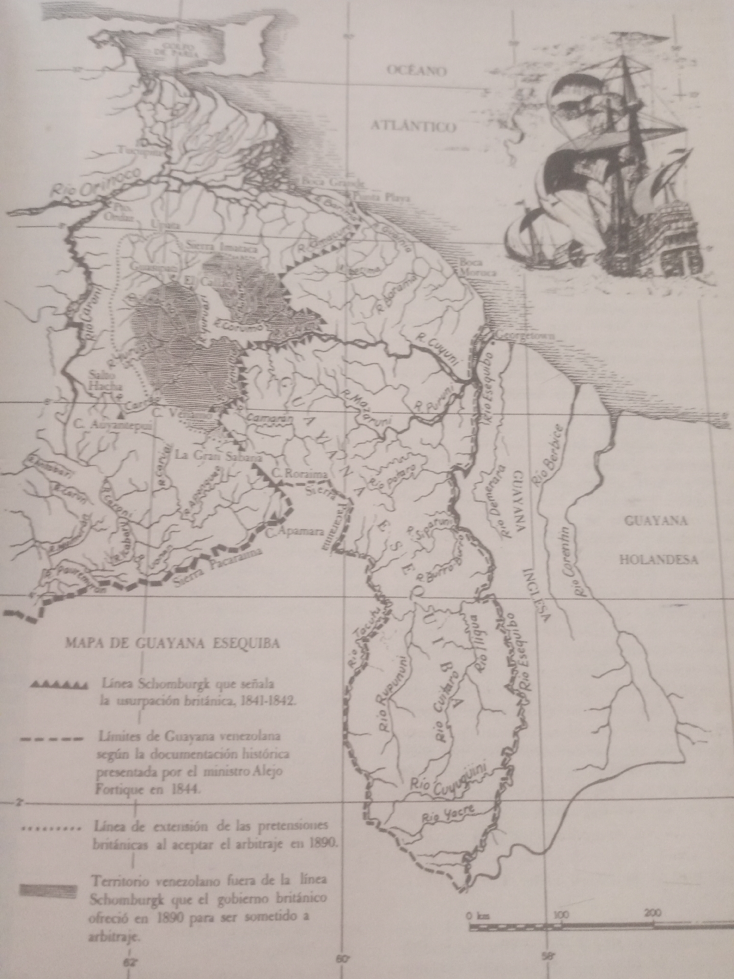
This image is a historical map titled "MAPA DE GUAYANA ESEQUIBA." The map depicts a geographical region with various rivers, mountains, and settlements. A significant feature is the representation of disputed territories and borders, indicated by different line styles and explanatory legends. One legend denotes the "Linea Schomburgk" which signals British usurpation between 1841-1842. Another shows the "Límites de Guayana venezolana" according to historical documentation from 1844. A third legend illustrates the extent of British claims after accepting arbitration in 1890, and a fourth highlights Venezuelan territory outside the Schomburgk line that was offered for arbitration.

Prominent geographical features labeled include the Rio Orinoco, La Gran Sabana, C. Roraima, and numerous other rivers like Rio Cuyuni and Rio Esequibo. Settlements such as Georgetown are also marked. The map includes a scale bar indicating distances in kilometers. In the upper right corner, an illustration of a historical sailing ship is present, possibly symbolizing exploration or naval presence in the region. The map appears to be in black and white, with a faded, aged quality. The text is in Spanish. The overall impression is one of a detailed cartographical document related to territorial claims and historical boundaries in the Guayana region.
cucha

Jun 23, 2026, 11:20 AM

Santa Ana, Venezuela

Stake attention in this memory

historical
geographical
political
maritime
territorial

This image is a historical map titled "MAPA DE GUAYANA ESEQUIBA." The map depicts a geographical region with various rivers, mountains, and settlements. A significant feature is the representation of disputed territories and borders, indicated by different line styles and explanatory legends. One legend denotes the "Linea Schomburgk" which signals British usurpation between 1841-1842. Another shows the "Límites de Guayana venezolana" according to historical documentation from 1844. A third legend illustrates the extent of British claims after accepting arbitration in 1890, and a fourth highlights Venezuelan territory outside the Schomburgk line that was offered for arbitration. Prominent geographical features labeled include the Rio Orinoco, La Gran Sabana, C. Roraima, and numerous other rivers like Rio Cuyuni and Rio Esequibo. Settlements such as Georgetown are also marked. The map includes a scale bar indicating distances in kilometers. In the upper right corner, an illustration of a historical sailing ship is present, possibly symbolizing exploration or naval presence in the region. The map appears to be in black and white, with a faded, aged quality. The text is in Spanish. The overall impression is one of a detailed cartographical document related to territorial claims and historical boundaries in the Guayana region.

Loading AttnAds…

transactions
revenues
stakers
Earliest
Latest
Highest stake

No transactions found

More from this user

More from Santa Ana

cucha

Jun 23, 2026, 11:20 AM

Santa Ana, Venezuela

Licensed under Creative Commons Attribution 4.0 International License. You are free to share and adapt this content with proper attribution.