Sign in
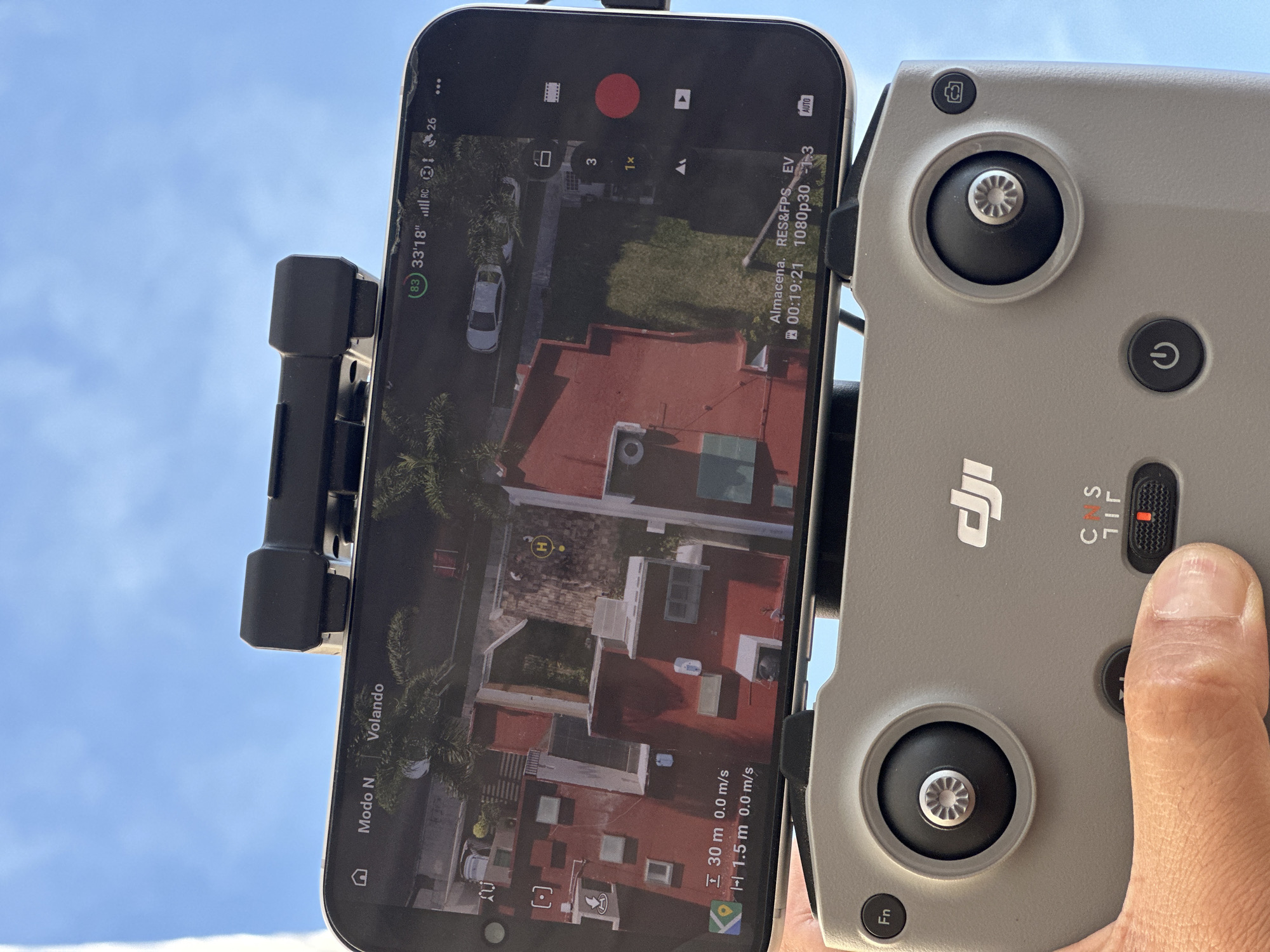
The image displays a close-up, high-angle view of a person operating a drone, focusing on a DJI remote controller with a smartphone mounted on top. The controller is gray, featuring joysticks, a power button symbol, and a camera/video toggle button. A right thumb is positioned near a red-tipped three-position switch, indicating flight modes C, S, and N.

The black smartphone, mounted directly above the controller, shows a live aerial feed from the drone. The screen displays a top-down view of a residential area, including buildings with red and white roofs, green patches, palm trees, and parked cars. An 'H' symbol marks the drone's home point.

Overlaid on the screen are various flight details and settings in white text. These include:
- Flight status: "Modo N" (Normal Mode) and "Volando" (Flying).
- Drone metrics: Altitude "30 m 0.0 m/s" (30 meters high, 0.0 m/s speed) and "1.5 m 0.0 m/s" (likely vertical distance from home point, 0.0 m/s speed).
- Battery and signal: A green circle with "83" (83% battery), "33'18"" (possible GPS coordinates or drone position data), and full "RC" signal bars.
- Recording information: A red circle indicating recording is active, a timer "00:19:21", "Almacena." (Storage), "RES&FPS" (Resolution & Frames Per Second), "1080p30" (1080p at 30 frames per second), and "EV -1.3" (Exposure Value). Other camera settings like "AUTO" and "1x" zoom are also visible.

The scene takes place outdoors on a bright day, indicated by the clear blue sky with some light clouds visible in the background. The Spanish text on the screen, such as "Modo N," "Volando," and "Almacena," suggests the user or drone operation is within a Spanish-speaking region, consistent with the provided location context of San Andrés Cholula, Mexico.
Mr.Sir

Apr 28, 2026, 11:24 PM

San Andrés Cholula, Mexico

Stake attention in this memory

excitement
anticipation
curiosity
control
adventure

The image displays a close-up, high-angle view of a person operating a drone, focusing on a DJI remote controller with a smartphone mounted on top. The controller is gray, featuring joysticks, a power button symbol, and a camera/video toggle button. A right thumb is positioned near a red-tipped three-position switch, indicating flight modes C, S, and N. The black smartphone, mounted directly above the controller, shows a live aerial feed from the drone. The screen displays a top-down view of a residential area, including buildings with red and white roofs, green patches, palm trees, and parked cars. An 'H' symbol marks the drone's home point. Overlaid on the screen are various flight details and settings in white text. These include: - Flight status: "Modo N" (Normal Mode) and "Volando" (Flying). - Drone metrics: Altitude "30 m 0.0 m/s" (30 meters high, 0.0 m/s speed) and "1.5 m 0.0 m/s" (likely vertical distance from home point, 0.0 m/s speed). - Battery and signal: A green circle with "83" (83% battery), "33'18"" (possible GPS coordinates or drone position data), and full "RC" signal bars. - Recording information: A red circle indicating recording is active, a timer "00:19:21", "Almacena." (Storage), "RES&FPS" (Resolution & Frames Per Second), "1080p30" (1080p at 30 frames per second), and "EV -1.3" (Exposure Value). Other camera settings like "AUTO" and "1x" zoom are also visible. The scene takes place outdoors on a bright day, indicated by the clear blue sky with some light clouds visible in the background. The Spanish text on the screen, such as "Modo N," "Volando," and "Almacena," suggests the user or drone operation is within a Spanish-speaking region, consistent with the provided location context of San Andrés Cholula, Mexico.

Loading AttnAds…

transactions
revenues
stakers
Earliest
Latest
Highest stake

No transactions found

More from this user

More from San Andrés Cholula

Mr.Sir

Apr 28, 2026, 11:24 PM

San Andrés Cholula, Mexico

Licensed under Creative Commons Attribution 4.0 International License. You are free to share and adapt this content with proper attribution.