Dongola, Sudan
2 memories from Dongola, Sudan
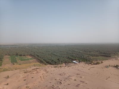
This aerial photograph presents a vast and contrasting landscape near Dongola, Sudan, showcasing the stark transition from arid desert to a fertile riverine oasis. The scene is dominated by a clear, pale blue sky with a hazy horizon, suggesting a bright, warm day. In the foreground, a sandy desert stretches across the lower half of the image. It features undulating terrain with sparse, low-lying scrub vegetation and scattered rocks. Visible within this desert landscape are utility poles and power lines, indicating infrastructure. On the right, a cluster of simple buildings includes one with a distinctive light blue dome, while further to the left, what appears to be ancient mudbrick foundations or ruins are embedded in the sand, hinting at historical habitation. The midground marks a dramatic shift to lush greenery. Extensive, rectangular agricultural fields are cultivated with varying shades of green crops and some patches of dried, lighter-colored vegetation, signifying active farming. These fields are bordered by a dense and expansive palm grove, likely composed of date palms, which forms a thick, verdant band stretching across the image. Several modest buildings are nestled within or alongside these green areas. In the background, a wide body of water, consistent with a major river, flows through the landscape, acting as the lifeblood of the oasis. On the far bank of the river, a distant town or settlement is discernible, blending with the hazy horizon. The image vividly portrays the essential role of the river in sustaining agriculture and human settlement within an otherwise arid desert region. There is no visible text in the photograph.
Dongola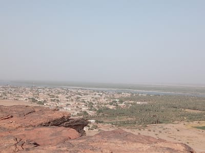
This panoramic image captures a sprawling landscape view of Dongola, Sudan, taken from a high vantage point, likely a rocky hill. In the immediate foreground, reddish-brown rock formations dominate the lower left and bottom edges of the frame. These rocks exhibit rough, weathered textures and layered geological features, typical of arid, ancient terrain. Moving towards the midground, a densely populated town or city unfolds, consisting of numerous light-colored buildings, predominantly low-rise structures, interspersed with scattered green trees. Roads and urban infrastructure are visible throughout the settlement. A few tall, slender communication towers can be seen rising above the buildings in the town area. Beyond the town lies a wide, placid body of water, identifiable as the Nile River, which appears as a greenish-grey ribbon extending horizontally across the image. Its surface is calm, reflecting the hazy sky. On the far bank of the Nile, an extensive and verdant expanse of date palm groves stretches across the landscape, indicating rich agricultural activity supported by the river. These groves form a dense, dark green band contrasting with the lighter tones of the town and distant arid land. Beyond the palm groves, the land transitions back to a lighter, arid terrain before fading into the distant, indistinct horizon. The sky is a uniform, light blue-grey, appearing hazy, which suggests either atmospheric dust common to the region or a bright, diffused sunlight. The time of day appears to be daytime, possibly late morning or early afternoon, with no strong shadows. No specific human activity, individuals, or visible text can be discerned in the image. The scene portrays the symbiotic relationship between human settlement, agriculture, and the life-giving Nile River in an otherwise arid environment.
Dongola